Maritime 10: navigation
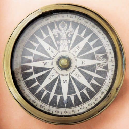
This is a ship's compass. A magnetic compass helps ships set a course to their destination, which can be plotted on a chart (a detailed map of the sea, coasts and harbours).
The letters denote the different directions, or points of the compass, with north at the top and south at the bottom.
Which other directions can you see?
This fine example, dating from about 1800, belonged to Captain John Elgar (1754-1829) of Folkestone who was captain of a hoy. Hoys were small sailing boats that carried passengers and cargo around the Kent coast and Thames estuary as far as London.
At sea, the helmsman was given a course to steer and then had to watch the compass and turn the ship’s wheel or tiller to keep the vessel heading in the right direction.
Ships’ compasses don’t have needles like pocket compasses. Instead the compass is fixed to the ship’s deck, housed in a special waterproof brass container called the binnacle.
As the ship changes direction, the compass card appears to rotate to indicate the new course the ship is heading.
In reality it is the compass housing (the outer brass casing) that turns with the ship. The compass card, balancing on a tiny central pin, stays pointing in the same direction, because ships’ compasses always point to magnetic north.
Did you know?
Before Global Position Finding (GPS) was available, navigational instruments were crucial in working out a ship’s position at sea, particularly when out of sight of land.
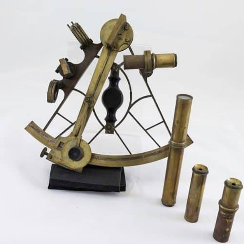
This beautiful brass sextant is a precision scientific instrument.
It was made in 1820 and belonged to an Arctic explorer who later became the Harbourmaster at Shanghai in China.
Can you find the Arctic and Shanghai on a world map?
It helped him navigate his way safely around the world’s oceans.
Sextants are used to work out your latitude (how far north or south you are on the globe) and (so long as you have an accurate ship’s clock or chronometer), your longitude (how far east or west you are).
How does it work?
A sextant works like a school protractor, by accurately measuring the angle (in degrees) the sun is above the horizon. This varies depending on your latitude.
To do this you look through the small telescope and take a sight of how high the sun or another celestial body (a bright star) is above the horizon. You also need to record the exact time you took the measurement.
With this information you then work out your exact position, using mathematical tables and charts.
Did you know?
Being able to know exactly where you are is crucial to safety at sea. Before Sextants, chronometers and modern GPS, accurate navigation was difficult, which led to countless shipwrecks.


